
 I’ve
I’ve
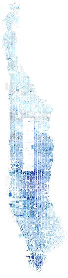
been staring for far too long at the map on the left, which can be seen in much
bigger format here.
It’s a map of the tax assessment value of the land in Manhattan, with the darker
areas being worth more dollars per square foot of dirt. Apparently Central Park
is assessed at $1.9 billion.A few things stand out:
Firstly, it’s a bit weird how, on this small island, the most valuable property
seems in general to be the property furthest away from the water. If you look
at Manhattan below 59th Street, there’s a clear strip of dark blue running down
the middle of the island, with values getting lower the further away from it
you get. Now, of course, since this is a map of values per square foot of lot
size, there’s going to be an extremely strong correlation between darkness of
blue and height of building. That’s why 3 World Financial Center and 4 World
Financial Center are darker than 1 World Financial Center and 2 World Financial
Center. But it’s certainly worth noting that most of the value of Manhattan
lies along a relatively narrow central strip.
It’s also fascinating to compare the Upper East Side and the Upper West Side.
The UWS is still very much the inferior side of the park, it would seem, and
especially Central Park West can’t dream of comparing itself to Fifth Avenue
or Central Park South. Plus, on the UES, the highest values seem to stretch
all the way over to 3rd Avenue, which is four blocks from Central Park. On the
UWS, virtually nothing has that kind of valuation.
That said, the UWS keeps its value much further north than the UES does. You
can see a very hard demarcation line on the UES at 96th Street, above which
you’re pretty much plunged directly into Harlem. Only 5th Avenue itself, it
would seem, has any real value on the UES north of there. On the UWS, by contrast,
the drop in values is much more genteel.
In terms of the practical meaning of this map, I wonder if it means that those
of us who live in the East Village, the Lower East Side and in Harlem should
be worried about an increase in the assessed value of our apartments. And, indeed,
if all of downtown between Chambers and 14th Street – definitely a more
expensive area, in terms of market value, than the Upper East Side – shouldn’t
share that fear. My East Village apartment has an assessed value of $33,689,
which is based on a "market value" of $80,848. I’m not sure how either
of these numbers are arrived at, but I fear what might happen to my property
taxes if either of them started being adjusted for reality.
Interesting how the Wanamaker Building pops out (as well as the Christadora House, but that’s to be expected). What’s interesting is that the plot that houses Discount Wines (or whatever it’s called) and Soup & Burger on B’Way right around the corner seems to be of equal value. There is the apt block adjacent to it, so perhaps that is what is skewing the numbers (even though the north tower on that block is showing as no data).
There was a good map in the Evening Standard showing house prices in London by area. It’s here, but unfortunately reproduced far too small to really see anything but overall trends.
http://images.thisislondon.co.uk/v2/news/londonpricemapL060105_450x332.jpg
Very pretty!
I had a look at land value in Manhattan (in the context of transit, don’t ask). In any case, it looked like much of value could be accounted for by zoning which does make quite a bit of sense. You can see those maps at….
http://sabinawolfson.com/misc/LandValueAndZoning.pdf
(You note the high values down the center of the island. This makes historical sense since land near the water was used for industry. Likely to change going forward?)
– Sabina
I assumed (as did Felix, I imagine) that the correlation between the midtown CBD and the highest valuations was self-evident. The areas with high value residential, even if they are more costly on a per square foot basis, still aren’t as dense.
Midtown has been the #1 CBD in the country for some time. Downtown lags behind several other cities at this point. And midtown exists not only because of excellent access to transit (both local and regional) but also because of geography — a high concentration of bedrock made large building construction much cheaper.
Property values are high near the center because not so long agao NY was a working port town, and the piers were not where you wanted to live. Noisy, smelly, frequented by drunken sailors etc. Once the subways, parks etc. were built in the middle they didn’t move once Manhattan shipping went into decline in the container/airliner era. A residential/recreational Manhattan waterfront is a recent phenomenon.
I thought the piers were basically along the Hudson from the W Village south, and then around the tip to about the Seaport. Other than that, I think the waterfront has always been residential.
And I thought the financial district was the third largest CBD in the country, after midtown and Chicago.
Hum, I think there were working piers along the east side too. And I think they went up reasonably high. Where are my old maps when I need them?
I have also been told that downtown is the 3rd largest CBD (midtown first, Chicago second). Don’t know that I have ever seen any numbers to back this up though.
Not a great map to make my point, but a BEAUTIFUL map none the less. Go to http://docs.unh.edu/nhtopos/Brooklyn.htm
and look at the “northwest corner” map and if you zoom in, you can see pier after pier on the east side of Manhattan past 20th St at least. I think these piers just expanded and grew over the next bunch of years. Think about it, before trucks took over shipping, everything had to get into Manhattan via boat (since the rail situation was and is insane). So those are going to have been very busy working piers.
As I remember, the piers on the Hudson stopped short of 72nd.
Land values are and have been studied quite thoroughly (with enough jargon and tedious detail to easily make one sleepy) — in urban planning, urban geography and urban economics. There is actually very little “mystery” to this map after one takes “Urban Planning 101.”
Basically, land values are a result, naturally, of how much money one can make off the land. Generally speaking, land at the center of any “traditional” city (i.e., non-freeway city) is going to have the highest value. Since Manhattan is a long, narrow island, this principal is “stretched out.”
As has been mentioned already, NYC was once a port city, and shipping AND other industries (e.g., gas works, power plants, foundries, slaughter houses, refuse transit stations, wholesale markets, ferries, bridge approaches, etc.) used to be located near the waterfront).
Plus all cities have vectors of fashionable growth (high rent districts). In NYC, the vector of fashionable growth was up Broadway and, later, Fifth Ave. In part this was because they were furtherst away from the waterfront, but in part it was also probably because of the ridge of high ground that goes up the center of Manhattan — which was important in terms of water runoff, etc.
In the modern day city, mass transit lines are also important in determining the value of land. Most of the mass transit lines (elevateds and subways) were built towards the center of the island. Also, those in the center were the least likely to be torn down (like the Third Ave. “el” and the Ninth Ave. “el”).
– – – – – – –
Although Manhattan’s waterfront was essentially, until recently, thought of as primarily commercial/industrial for virtually its entire perimeter, NYC’s economy never actually grew that large. As a result, the piers “died out” at about 50th (?) street (with the Cunard piers) on the West Side and, I think, at about Houston St. (?) on the east side. I believe in the sailing ship days the East “River” (a tidal strait) was the better port, but that in the steamship days the Hudson “River” (which along this stretch is considered an “estuary”(?) was considered the better (deeper draft?) location.
I think the last working East River piers (used until the mid-1960s?) were used by freighters that carried bananas. The last working Hudson River piers are the passenger superliner piers that were re-built in the early 1970s (and originally built in the late 1920s?).
A “funny story”: When the superliner piers were built to accommodate ships like the Queen Mary and the Normandie (which were on the drawing boards), it was discovered that the city didn’t have enough room for piers of the required length. Any pier long enough was going to jut into the Hudson River past what the Coast Guard (?) Corp of Army Engineers (?) would allow. So Mayor Jimmy Walker was supposedly asked what to do, and he supposed answered in a snap something like, “Build them inland, the Army Corps of Engineers can’t do anything about that!” (In other words, dig chanels into the western edge of Manhattan Island in order to make the piers “long” enough. So, if you look at a map of Manhattan, you can see that the berths for the ocean liners cut into the west side of Manhattan.
But in addition to piers, as I mentioned, there used to be quite a bit of “dirty” manufacturing along the riverfronts. I believe, for instance, that on the site of the UN there were slaugher houses — which is why the Tudo City apartment development has only stairwell windows, etc. overlooking the UN site.
Along the Harlem River there used to be these incredible junk yards with cars piled high on top of one another. It used to be one of the biggest “highlights” for tourists taking the Circle Line cruise around Manhattan.
# # #
One other interesting “tidbit”:
There were a few exceptions to industrial/commercial, “low rent” residential usage of the waterfront, most notably the Beekman Place/Sutton Place area on the east side.
But I believe even this area was mostly “low rent,” but for some reason in the 1920s(?), or so, it became more and more poplar for wealthy people.
But since it had “originally” been “low rent,” there were still a lot of poor people in the area and there was a striking contrast between the “lower classes” in the tenements and the very rich in the new high rise-apartments (like “River House,” where Henry Kissinger now lives, I believe).
This incredible contrast was used in the play by Sidney Kingsley (?) called “Dead End.” The stage set for the play had the back of a “ritzy” apartment house on the left side of the stage and the facades of some “low rent” tenements on the right. The front of the stage was supposed to be the pierhead lin, and the kids in the cast would periodically jump into the orchestra pit and water from buckets would be thrown up on the stage to simulate a splash effect.
I believe the movie version was so popular that it gave rise to a series of “Dead End Kid” light/comedy movies (which used to be shown on TV).
# # #
Speaking of the “devil”: There’s a very interesting article about the West Side Piers in the on-line edition of the “New York Times.” The article is dated, Sunday, March 12th, and is in the “The City” section of the Sunday paper: “Citylore: Sailing Away,” by John Maxtone-Graham. It includes the story about cutting into the West Side of Manhattan in order to “lengthen” the superliner piers.
John Maxtone-Graham is a maritime historian who wrote a wonderful book about the trans-Atlantic ocean liners, “The Only Way to Cross” — which is where I may have read this story to begin with.
Hello everybody
maybe you could give me some references to look for about land value in manhattan, or anything related to the subject, anecdots…
thanks